hotels in Krakow

restaurants in Krakow

travel to Krakow

Krakow Info

Krakow Street Map 

information about Krakow in Poland - attractions & entertainment & culture & business & nightlife & transport & shopping & art & music & theater & museums & landmarks & curios & lifestyle & education & festivals & customs & tours & people

Krakow Info website doesn’t use cookies nor gathers personal data but advertisers and services providers may do it on their own responsibility. Privacy policy.

Please link to each webpage of Krakow Info website as you wish. We give permission to all hyperlinks and there is no need to ask.

Krakow info logoKrakow Info home page


Krakow
for mobile
devices


facts


joys
sights
events
musts
hubs


business


food
hotels
travel
buys


tips


Your
Questions
Answered

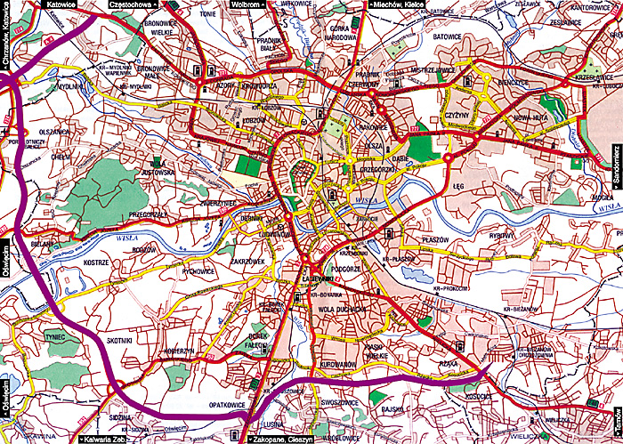
Map of the city of Krakow

Krakow City Map, the Streets. 

Roads: expressway A4 in purple, primary arteries in red, secondary arteries in yellow, main streets in white, other streets in brown.
Railroad trunk-lines in black. Rivers, lakes and other reservoirs in blue.
Residential areas as salmon-colored patches.
Parks as patches of dark green, forests as patches of light green. Cemeteries as patches of pale green with dots.
City limits as dashed black line.


Map of the Old Town Historic District

Map of the Main Roads in Krakow

Map of parking zones and parking lots in downtown Krakow


Poland Map

Malopolska Province Map


Krakow hotels and other accommodations

There are 17,000 beds to choose from.

Krakow Restaurants
Krakow is Poland’s mecca of gourmets thanks to its many excellent restaurants.


Krakow Info HOME PAGE

Copyright © 2001-2018 by MAREK STRZALA. All rights reserved.